Contents
Index
Control Points
This option allows the user to add, delete or change control point data.
The coordinates for all control points must be on the same
datum and zone as specified for the job. Heights are optional, but if they are specified they will
be used.
Datum/Zone
This field displays the datum and zone if one has been selected for the Plan.
Points List
This field displays the Point Number, Control Point Name, whether it is active or not, the Residuals and the
Status of the point.
Active - You can make a point Active or Non-Active by clicking on the check box in the list.
Select - You can select control points by cliucking on the row.
Hold down Control/Shift to select multiple control points.
Add
Allows you to add a new control point to the list.
Every point must have a name, and horizontal coordinates (Easting and Northing).
See this page for details.
Delete
The Delete button will delete the control point selected in the window of the control box.
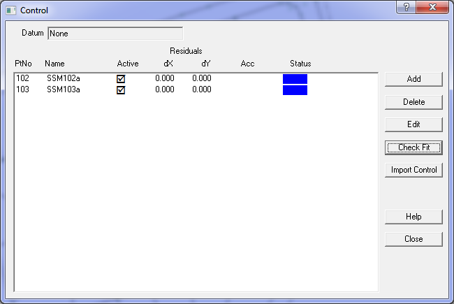
Edit
This nwill edit the selected control point. You can change any of the control point attributes.
Check Fit
This option computes how the active control points 'fit' to the current points in the job.
A “least squares” procedure is used to compute transformation parameters between the control point
system and the current parcel coordinates. This transform is then applied to the cadastral points
associated with each control point and the residuals (control point value minus the computed value)
is shown in the Control Points list.
The dx, dy columns show how the new coordinates fit with the existing network.
Any control points that have large residuals should be investigated before proceeding.
If there are any doubts with regard to any control points, they should be made inactive
before proceeding with the adjustment
If only two control points are used, always check that both the scale factor and azimuth swing for
the transformation are reasonable before proceeding.
Import Control
Allows you to import control points from an external file or another job.
A control point master file can have all the control points for a locality that may cover
a number of parcel ‘areas’.
The file may be the output from a geodetic adjustment or from a GPS system.
The coordinates from that file will be read in and used to update the
coordinates for control points in the job.