Contents
Index
Distances - Annotated Plan
The Distances tab is used to display set the font, colour and style of the Distances text
to be generated for string lines.
To compute the annotated plot, follow these steps:
1. Turn on or off any required options for Lots, areas, bearings, distances etc
2. Press APPLY or OK to generate the annotated text.
Distances
This check box allows the user to turn on or off the Distances.
Note that the Distances text is generated and inserted into the job just like any other
piece of text. It can then be edited and altered at will.
This can also be turned on/off from the ‘Annotated Plot’ tab.
Note: When the lot string is changed the Distances text will NOT be updated.
You must select the Annotated Plan option and re-generate the Distances text.
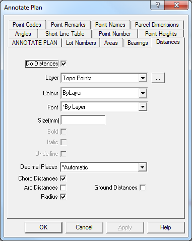
Layer
Select the target layer on which the Distances text will be placed. Press the [...] button to create a new layer.
Note that the Distances text may be generated using the font, text size and colour of the
layer it is placed on. This allow you to easily change the size, font or colour of all the
distance text by directly changing the layer attributes.
Colour
Select the colour of the Distances text, select ‘*ByLayer’ if you want the distances text to
use the same colour as the layer text.
Font
Select the font of the Distances text, select ‘*ByLayer’ if you want the distances text to use the
same font as the layer text.
Size
Select the text size in mm for the Distances text, leave this field blank if you want the Distances
text to use the same text size as the layer text.
Bold
Tick the bock if you want Bold text.
Italic
Tick the box if you want Italic text.
Underline
Tick the box if you want Underlined text.
Decimal Places
Select the number of decimal places to be used in the distances values. The distance will be
ROUNDED to this number of decimal places. Select ‘*Automatic’ to allow the program to automatically select the number of decimal places.
Note: For the Sale Plan if the number of decimal places for the distances are set to ‘Automatic’,
the distances will be TRUNCATED (Lopped off) to 0.1 metres. Note that if you select a certain number
of decimal places (say 2), the distance will be ROUNDED to the required number of decimals.
Chord Distances
Tick the box if you want Chord distances displayed for curved lines
Arc Distances
Tick the box if you want Arc distances displayed for curved lines
Radius
Tick the box if you want the Radius displayed for curved lines
Ground Distances
Tick the box if you want the Ground Distances displayed instead of Grid(Plane) distances.
Note: ground distances are calculated for line lengths (distances), chord distances, arc distances,
chainages and areas. When calculating the ground distance for a line, the height of either or both of
the end points are used to adjust for height. If neither point has a height, it uses the closest
point in the job with a height value.
If no datum has been specified, grid distances will be calculated in any case.